| |||||||||||||||||||||||||||||||||||||||
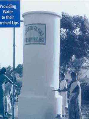
This page will discuss Sathya Sai Baba's project, begun in 1994, which brought water to more than 700 villages in the the Indian state of Andhra Pradesh (where Prashanthi Nilayam is located). This project was directed by the Sri Sathya Sai Central Trust and carried out by Larsen & Toubro Limited, with the collaboration of the Government of Andhra Pradesh. The project cost over U.S. $63 million, which was donated to the Sri Sathya Sai Central Trust without any kind of solicitation.Avatars are engaged in selfless service (seva); that is why Avatars happen. Offering service to mankind pleases Avatars. ... I am active and busy twenty-four hours a day. ... I have never craved a minute's rest or sleep or relief. For the moment, here are some statistics on the project. Project highlights
Construction highlights
Details of villages
| |||||||||||||||||||||||||||||||||||||||
Sunday, 27 November 2011
Sri Sathya Sai Drinking Water Supply Projects
Tourism near to regatipalli village
| Tourism | |||
| |||
| Dharmavaram | |||
| How to Reach | |||
Dharmavaram is located at a distance of 46 km from Ananthapur and 200 KM from Bangalore . This place is well connected by rail and road. Private transport facility is available from Ananthapur. | |||
| Significance | |||
Historical Significance : There is historical evidence to prove that it was ruled by Bijayanagar Vidya kings for nearly 500 years from 1075 Satavahana Saka. Dharmavaram tank is one of the large tanks in Anantapur district. Sri Kriyasakhti Wadiyar, who constructed the tank, built a village in memory of his late mother Dharmamba and named it Dharmavaram. | |||
Temples: Dharmavaram is famous for the temple of Sri Lakshmi Chennakesava Swamy . Temple is renowned for its architectural brilliance and for the perennial waterspout and pillars The temple has a multi-storied tower, extensive enclosures and an entrance carved in the Vijayanagar style. The architecturally exquisite Ramalingeswara Temple has a perennial water spout and seven independent pillars which produce seven different musical notes when struck. | |||
Silk Sarees: Dharmavaram is also known for its cotton and silk weaving industry. Dharmavaram silk sarees are well known all over the country. Leather puppets are also made in the vicinity. It is famous for silk sarees and has a great past. Thousands of families depend on the silk industry, for which Dharmavaram attained fame. there are more than a thousand shops in the town, which sell silk sarees. nearly 30 silk cooperative societies help those enganged in the trade. This silk-were is exported to Germany, France and other countries abroad. Only in Dharmavaram exists a Silk Exchange. Many freedom-fighters belong to this place. | |||
| |||
| » Gooty | |||
| How to Reach | |||
Gooty is located at a distance of 52 km from Ananthapur on the Kurnool-Bangalore trunk road. It is one of the oldest hill forts of Andhra Pradesh. This place is well connected by rail and road from Ananthapur. | |||
| Significance | |||
Gooty fort is situated at a height of 300 mtrs above the plains in Gooty. It is one of the oldest hill forts in Andhra Pradesh. The fort was built by the emperors of the Vijayanagara Kingdom . The Marathas under Murari Rao conquered it. Then it was taken over by Haider Ali in 1773 and eventually fell into the British hands after the defeat of Tipu Sultan in 1799. The fort was built in the shape of a shell and has 15 forts with 15 main doors (mukahdwarulu) inside the structure. There is a small pavilion made of polished lime stone called Murari Rao's seat. This pavilion is on the edge of a cliff from where one can have a panoramic view of the surroundings. The unique feature of the fort is the availability of water resources at such a height. | |||
| |||
» Hemavathi | |||
How to Reach | |||
Hemavathi in Ananthapur district is situated at a distance of 37 km from Madakasiri and 148 km from Ananthapur. Hemavathi is well connected by road with frequent bus and private transport facilities from Madakasiri. The nearest railhead is at Hindupur. | |||
| Significance | |||
Hemavathi was once capital of Pallavas during the 9th -10th centuries. It is a repository of a striking collection of Pallava and Chola architecture.Hemavathi assumed considerable importance between the 9th and 10th century AD, under the Nolamba Pallavas when it was known as Henjeri.Nolambas or Nodambas trace their descent from a mythical demon of that name. Trinayana Pallava or Mukkanti was regarded as the founder of this royal line. Nolamba rulers were known for their patronage for arts and religion.Hemavathi is famous for the temple of Doddeswara Swamy . A Nandi made of black basalt granite 8 feet in length and 4 feet in height, sits at the entrance. There is a 6 feet tall Lingam installed inside the sanctum sanctorum.Jain devotees from all over India converge annually on teh Jain temple located in hemavati. | |||
| » Penukonda | |||
| How to Reach | |||
Penukonda is 50 km from Ananthapur and is located on the way to Bangalore (on National Highway No. 7). It is well connected by road with frequent buses and private transportation from Ananthapur. | |||
| Significance | |||
Penukonda is mentioned as Ghangari in the local inscriptions. The structure of the fort shows the splendid plan and strategic view of the medieval period. There are a good number of temples in the Fort. The Penukonda Fort, constructed with stone by mixing lime and clay, served as the capital of the Vijayanagara Empire for a short period and remained inaccessible to the enemies. Now, there are two important sights here. One is the "Gagan Mahal" which was used as a summer resort by the Vijayanagar Kings. The Gagan Mahal witnessed the majesty and aristocracy of the Royal times and was built in 1575 AD. The other is "Babayya Darga" which is the symbol of communal harmony between Hindus and Muslims. | |||
| |||
| » Lepakshi | |||
| How to Reach | |||
It is the most important place in the Anantapur District from the historical and archaeological point of view . Lepakshi is situated at a distance of km from Bangalore and 110 km from Ananthapur. Lepakshi is well connected by road with frequent bus and private transport facilities from Hindupur at the distance of 15 KM. The nearest railhead is at Hindupur. The Skandhapuranam refers to Lepakshi as one of the 108 Saiva temples in India . Sri Virupanna, who worked as a Treasury Officer of Penukonda Fort of Vijayanagara Empire, took up the construction of the Lord Veerabhadhra Temple at Lepakshi in the 16th-century. One can find the late Vijayanagara style of architecture in the vestiges of Lepakshi. The construction of the temple in 1538 A.D. is attributed to Virupanna, a noble man and merchant prince of those times. The natyamandapa or dance hall is supported by 100 pillars finely sculpted with figurines of a dancing Siva, Nandi, Tumbura, Rambha and other celestial beings playing the drum, veena and other instruments in accompaniment. The unfinished Kalyanamandapa on the other side contains sculptures of dikapalakas on the pillar. From the centre of the mantapa emerges a dome, twenty-one feet high, like a great lotus of heaven. In this huge mantapa, the ceiling is divided into different panels by beams that are painted with some of the most exquisite murals of the Deccan. | |||
| |||
| » Tadipatri | |||
| How to reach | |||
| Tadipatri is Located at a distance of 90kms, from Ananthapur. | |||
| Chintala Venkataramana Temple | |||
Tadipatri has many religious monuments of interest located in and around the town. In the heart of the town is the Chintala Venkataramana Temple with its lofty gopura. At a distance of 1km, from the town, overlooking the Pennar river is the Bugga Ramalingeshwara Temple, remarkable for a lingam on a pedestal, constantly filled with water from a small spring. | |||
| Aluru Kona | |||
| |||
This village is at a distance of 5 Km. from Tadipatri Twon. It is said that Yerramraju, the chief representative of King Bukkaraya, Built Ranganathaswami temple, in 1334 A.D., Atop a hill. One can find a small water falls in an area in the valley, where water is ever-present. The vlley with its natural beauty attracts toursts. Apart from that, thousands of tourists and devotees visit it throughout the year. "Brahmotsavam" of Lord Ranganathaswami is celebrated on Chaitra Sudha Paurnami Day. | |||
| |||
| » Penna Ahobilam | |||
| How to Reach | |||
Located at a distance of 12kms, from Uravakonda and 36kms, from Anantapur, it is well-linked by road with frequent bus service. | |||
| Sri Lakshmi Narasimha Swamy Temple | |||
This Temple is located amidst lush greenery, on the banks of a rivulet of Pennar. Myth has it that this temple was built on the footprint of Lord Lakshmi Narasimha Swamy measuring 5 feet 3 inches . And it is said that another footprint of the Lord is at the Ahobilam temple in Kurnool district. According to the sources available, Most of the people visit this place to perform marriage ceremonies of their children and relatives. A grand car festival is conducted in the month of April. | |||
| |||
| » Thimmamma Marrimanu (Banayan Tree) | |||
| How to Reach | |||
| Located about 35 kms from Kadiri, and 100 kms from Anantapur. | |||
| Significance | |||
it is famous as it has a banyan tree, which is locally called as "Thimmamma Marrimanu''. It is regarded as the biggest of its kind in South India. It's branches spreads over nearly 5 acres. It is named after 'Thimmamma' who was considered to be the representative of the Almighty. To the pride of India, the "Marrimanu" was recorded as the biggest tree in the Guinness Book of World Records in 1989. A small temple dedicated to Thimmamma lies under the tree. An account of this lady in Telugu kept at the shrine reveals that she was the daughter of a Setti Balija couple Sennakka Venkatappa and Mangamma, born in AD 1394. She was married to a Bala Veerayya who died in 1434, and Thimmamma committed 'Sati'. The banyan tree is believed to have sprouted at the place where she ascended the funeral pyre. The people of this area strongly believe that if a childless couple worship "Thimmamma" they will have a child the very next year. A big 'Jatara' is conducted here on the day of "Shivaratri" when thousands and thousands of people flock here to worship 'Thimmamma' on this occasion. | |||
| |||
| » Kadiri | |||
| Sri Lakshmi Narashimha Swami Temple | |||
is located to the west of the town and is a popular place of pilgrimage attracting devotees even from neighbouring districts. The epics say that 'Narashimha Swami' is one of the ten avataras of Lord Vishnu. This Vishnu temple appears to have been constructed by one 'Ranganayudu', a Palegar of Patharlapattanam. Several scenes from 'Ramayana' are painted on the ceiling of the 'Rangamantapa' and several frescos on that of the Lakshmi mantapa depicting scenes from the 'Bhagavata'. Unfortunately the murals have lost their freshness and are fading. Many inscriptions on the temple mostly mention the gifts given by kings to the temple. The legendary significance of this sacred shrine dates back to Trethayuga, and according to local version, the presiding deity - Narasimhaswami in His terrific aspect - 'Vugrarupa' chose to settle down here after killing Hiranyakasipu. | |||
| |||
| » Puttaparthi | |||
Puttaparthi, now popularly known as Prasanthi Nilayam, the abode of Supreme Peace, is the home town of Bhagawan Sri Satya Sai Baba and it is about 40 km away from Dharmavaram, 80 km from Anantapur and 200 km from Bangalore . World renowned and worshipped by His devotees all over the globe as God Incarnate, Sri Sathya Sai Baba has shown humanity a new way of life and through His simple teachings transformed millions of His devotees' lives. It indeed needs a divine intervention for anyone to achieve the accomplishments of Sri Sathya Sai Baba. Prasanthi Nilayam, the abode of supreme peace, is a place every human being should visit in his lifetime to experience for oneself what selfless and pure love can achieve. This is the abode of Sri Sathya Sai Baba and it lies on the bank of the river Chitravati, at a distance of 90Km. from anantapuram and 20Km. from penugonda. He is comsidered the incarnation of Sri Shirdi Sai Baba and thousands of devotees and tourists from the four corners of the world visit Puttaparti just to have his 'darshan'. Places of importance here are Prashanti Nilayam, Purnachandra auditorium, Planetarium, Superspeciality hospital,museum and Satya Sai Deemed University . The Deemed University was established 17 years ago, to disseminate knowledge to many and with the commendable onjective of providing education to one and all, transcending the barriers of caste,religion and region. Sri Sathya Sai Institute of Higher leaning,which is a part of it,seeks to mould every child as the darling of the goddess of learning and has many successes behind it. The education imparted in this institute covers a wide range from the kindergarten stage to the postgraduate stage, including medicine. The Satya Sai colleges established in prasanti Nilayam,and Whitefield and Anantapur. In order to quenchthe thirst of the villages in the district, Bhagawan Satya Sai Baba conceived a scheme for supply of drinking water at a cost of crores of rupees. Under this, schemes have been established for community protected water supply plans and independent protected water supply plans. These plans cover 34 mandals in the district and are extended to villages which have flouride-free water. 3 lankhs of residents of 301 villages are the beneficiaries of his laudable plan. The panchayats of the respective villages are entrusted with its implementation. For implementation of these shcemes, pipelines measuring hundres of kilometres have been laid. The Board of Satya Sai Water Supply Plan, established by the State Governemnt, is vested with authority to oversee everything. | |||
| http://www.sathyasai.org/ | |||
| |||
| » Yogi Vemana Samadhi | |||
Famous for the Yogi Vemana Samadhi, Kattarupally attracts a lot of pilgrims. Situated 25 kms. from Kadiri enroute Thimmamamarimanu, the journey offers spectacular views of rock formations of various shapes. Yogi Vemana is widely known as peoples' poet. His simple and colloquial Telugu poems, which narrates truths of day to day life and social evils, are more popular among the literates and illiterate ruralites. | |||
| |||
| » GUGUDU | |||
| |||
The village in Narpala Mandal is at a distance of 29 kms from Anantapur and is situated among the Mutchukota Hills. It is known for its Moharum Festival and Sri Kullai Swamy is the name of the much venerated saint. Barren women are said to become fertile by paying a visit to the shrine. Fire walking ceremony is conducted on the night of the 11 th day of Moharrum. There is also Sri Anjaneya Swamy Temple near by the abode of Sri Kullai Swamy Chavidi. | |||
| |||
| » Yadiki Caves | |||
Yadiki is midway between Gooty and Tadipatri. The cave system is in the picturesque village of Konapulappadu which is 18 kms. From Yadiki. The magnificent view of the hillocks, gorges, spring, paddy fields, lake and winding roads enthralls every visitor. Geemanugavi cave is 5kms. In length and one can go up to 2kms. Inside. The intricate designs of stalactite and stalagmite formations takes shape of chandeliers, bridges, globes, snakes etc. The sight of some, which glitters like diamonds is amazing. Uudamanugavi, another cave can accommodate 100 people . Kona Ramalingeswara temple adjacent to the spring adds to the beauty. For those who are young in mind and body there is scope for trekking and rock climbing. | |||


Dharmavaram Sarees
| Dharmavaram Sarees | |||||||||||||
| |||||||||||||
| For further Details Contact Asst. Director - Handlooms & Textiles | |||||||||||||
|


Famous Personalities IN anatapur district
| Famous Personalities In anatapur district | |||
|
| ||
| Sri Lakkoju Sanjeevaraya Sharma Renowned Mathematics Genius, who won 13 Gold Medals worldwide, and blind by birth. | |||
Ballari Raghav Ballari Raghava(1880-1946) Raghava Ballari was one of the greatest Telugu drama artists. He was born on August 2, 1880 in Tadapatri, a village in Anantapuram district. His father was Narasimhachari and mother was Seshamma. His religion was Vaishnava and belonged to a caste/tribe called Srivaishnava. He was married to Krishnamma, daughter of Lakshmanachari of Kurnool. He finished his Metric in Ballari High School and graduated from Christian College, Madras (now Chennai). He practiced law after graduating from Madras Law College in 1905. Very soon he became rich and popular as a criminal lawyer and well known for his cross examination tactics. The British Government recognized his talent and appointed him as a public prosecutor and also awarded him the title "Rao Bahaddur." From his childhood, he was very interested in drama and started his acting career at the age of 12. He founded Shakespeare Club in Ballari and played Shakespeare dramas. Raghava portrayed main characters in various dramas in Sreenivasarao Kolachalam's group called Sumanohara in Bangalore. Harischandra, padukapattabhishekamu, savitri, brihannala, ramaraju charitra, ramadasu, tappevaridi, saripadani sangatulu, etc. were his famous dramas. He visited various countries like Sri Lanka, England, France, Germany and Switzerland and gave seminars and lectures on Indian drama art. He was also invited to America and Russia, but he was unable to go to these countries. Eminent people like Mahatma Gandhi and artists like Rabindranath Tagore were impressed by his dramas. He was very popular among the common people as well. He encouraged women to participate in drama. His students who later became very popular included female artists like Sarojini Kopparapu, Padmavati Kommuri and Annapurna Kakinada, and male artists like Vasudevarao K.S., Apparao Basavaraju and Kanaklingeswarrao Banda. He flirted with film industry briefly. In 1936, he played Duryodhana in Reddy H.M.'s "draupadi maana samrakshanam." He also acted in raitubidda and chandika. However, he quit the film industry quickly. Raghava was influenced by a spiritual master Pandit Taranadh who established an ashram on the banks of Tungabhadra river and contributed a lot to this ashram. He used to provide financial help to anyone in need. He was against traditional extravagant marriages and ghettoism. He lived a simple life, in spite of his tremendous wealth. He believed that music should be down played in drama and social dramas related to social reforms should be given more importance. He advocated that drama should bring some social benefit to the society, in addition to entertainment. He continued his interest in drama until his last day on April 16th, 1946. A prestigious award "Ballari Raghava Puraskaram" was instituted in his memory and is awarded to talented artists who contributed to drama and cinema. | |||
Sri Tarimala Nagi Reddy: ( February 11, 1917 - July 28, 1976 ), often called "TN" was a communist politician from Andhra Pradesh, India. T.N. Reddy was born in Tarimela in Anantapur District. He studied at Loyola College in Madras and at Banaras Hindu University in Varanasi . During his student days he got involved with nationalism and Marxism. His political activities got him jailed in 1940, 1941 and 1946. Reddy was elected to the Madras legislative assembly, as a communist candidate, in 1951 . He was elected to the Lok Sabha from Anantapur in 1957 . In 1962 he was elected to the Andhra Pradesh legislative assembly as a Communist Party of India candidate from Putloor . In 1967 he was again elected to the assembly | |||
Sri SANJEEV REDDY LAKSHMAYYA PAIDI (DR.) M.A.P.HD., I.A.S. | |||
He has 35 years of experience in various capacities in the Indian Administrative Service and retired as Secretary to Department of Company Affairs. He has won National Awards for his Managerial Excellence in several fields. During his service, he has held various positions viz., District Collector, Secretary to various ministries of the Government, VC and MD - A.P. State Agro Industries Development Corporation Ltd., APIDC, APSFC and A.P. State Non-Resident Investment Corporation. He was the Principle Secretary to the Chief Minister, Govt. of A.P., during 1988 to 1989. He was also the Secretary to the erstwhile M.R.T.P. Commission during 1990 to 1992. He was Ex-Officio Additional Secretary to D.G.F.T. during 1993 to 1995. He was Director General of the Indian Institute of Foreign Trade during 1995 to 1997. He was the Principle Advisor to the Planning Commission of the Govt. of India during 1999, and was Secretary to the Govt. of India, Dept. of Rural Development during 1999 to 2000. Sri Sathya Sai Baba Passes away Spiritual leader Bhagawan Sri Sathya Sai Baba passed away at Puttaparthi in Anantapur district of Andhra Pradesh on Sunday i.e. 24/04/2011 morning. He was 85 years Old. The body of Sathya Sai Baba kept in Sai Kulwant Hall in Prashanthi Nilayam in Puttaparthi. Hon’ble Chief Minister and Hon’ble Governer came to Puttaparthy to pay their final respects to Swamy Ji. Hon’ble Chief Minister declared State mourning for four days and a holiday in Anantapur district on Wednesday. He said Sai Baba would be given State honours at the funeral. All the dignitaries in the country paid their tributes to Swamiji. The mortal remains will be kept in Sai Kulwant Hall on Monday and Tuesday for devotees to pay their final respects. | |||

DHARMAVARAM DIVISION MPDO LIST
| DHARMAVARAM DIVISION | |||||
| Sl.No | Mandal | Name of the MPDO | STD Code | Office | Cell No. |
| 1 | BATHALAPALLI | V.SHANKAR | 8559 | 242336 | 9493743106 |
| 2 | BELUGUPPA | V.BHAGYALAKSHMI | 8497 | 239239 | 9493743107 |
| 3 | BOMMANAHAL | T.NAGAIAH (FAC) SUPERINTENDENT | 8495 | 258738 | 9493743108 |
| 4 | BRAMHASAMUDRAM | P.DIWAKAR, (FAC), EO(PR&RD), BRAMHASAMUDRAM | 8497 | 288838 | 9493743109 |
| 5 | CK PALLI | C.L.SONI BAI | 8559 | 240336 | 9493743113 |
| 6 | DHARMAVARAM | K.BASHKAR REDDY | 8559 | 220134 | 9493743116 |
| 7 | D HIREHAL | M.S.BALAYOGI | 8495 | 238480 | 9493743115 |
| 8 | GUMMAGATTA | B.ROSHAN ZAMEER E.O(PR&RD),GUMMAGATTA(FAC) | 8495 | 236725 | 9493743122 |
| 9 | KALYANDURG | P.LAVANYA KUMARI | 8497 | 220042 | 9493743126 |
| 10 | KAMBADUR | C.VENUGOPAL NAIDU | 8492 | 280323 | 9493743127 |
| 11 | KANAGANAPALLI | M.PURUSHOTHAM | 8491 | 248231 | 9493743128 |
| 12 | KANEKAL | K.KAMALA | 8495 | 257128 | 9493743129 |
| 13 | KUNDURPI | C.BHGYAMMA | 8492 | 283039 | 9493743132 |
| 14 | RAMAGIRI | SREENIVASULU | 8491 | 249250 | 9493743148 |
| 15 | RAYADURG | G.VENKATA NAIDU | 8495 | 252018 | 9493743150 |
| 16 | SETTUR | V.GANGANNA | 8492 | 283550 | 9493743153 |
| 17 | TADIMARRI | P.RAMESH NAIK | 8559 | 246642 | 9493743156 |
DHARMAVARAM DIVISION Tahsildar LIST
| DHARMAVARAM DIVISION | ||||
| Sl.No | Mandal | Name of the Tahsildar | Office | Cell No. |
| 1 | Bathalapalli | S.Intiaz Ahmad | 08559-242338 | 9493188842 |
| 2 | Beluguppa | D Dastagiri (DT) (FAC) | 08497-239224 | 9493188847 |
| 3 | Bommanahal | G Sankaraiah I/c | 08495-258794 | 9493188856 |
| 4 | Brahmasamudram | K Jayarami Reddy (CSDT) (FAC) | 08497-288842 | 9493188850 |
| 5 | C.K. Palli | S Adinarayana | 08559-240330 | 9493188843 |
| 6 | D. Hirehal | G Sankaraiah | 08495-238370 | 9493188853 |
| 7 | Dharmavaram | P Ramachandra Reddy | 08559-222607 | 9493188840 |
| 8 | Gummagatta | K Sridhar (DT) (FAC) | 08495-236707 | 9493188854 |
| 9 | Kalyanadurg | Sivaji (DT) (FAC) | 08495-220046 | 9493188846 |
| 10 | Kambadur | Anwar Basha (DT) (FAC) | 08492-280272 | 9493188848 |
| 11 | Kanganapalli | S A Kaleel (DT) (FAC) | 08491-248336 | 9493188844 |
| 12 | Kanekal | Venkatasiva Prasad (DT) (FAC) | 08495-257148 | 9493188855 |
| 13 | Kundurpi | Ramasekhar (DT) (FAC) | 08492-283030 | 9493188849 |
| 14 | Ramagiri | B Saraswathi (DT) (FAC) | 08491-249291 | 9493188845 |
| 15 | Rayadurg | K Anjineyulu (DT) (FAC) | 08495-252002 | 9493188852 |
| 16 | Settur | D V Subramanyam (DT) (FAC) | 08492-283414 | 9493188851 |
| 17 | Tadimarri | S Raghavendra | 08559-246967 | 9493188841 |
Supdt., of Police
| Supdt., of Police | ||||||||||||||
|

D.I.G. of Police
| D.I.G. of Police | |||||||||||||||||||
| |||||||||||||||||||

Collector & District Magistrate -Anantapur
| Our Administrative Profile | |||||||||||||||||||||||||||||||||||||||||||||||
| |||||||||||||||||||||||||||||||||||||||||||||||


Historical Background Of Anantapur District
| Historical Background Of Anantapur District | ||||||||||||||||||||||||||||||||||||||||||||||||||||||||||||||||||||||||
Anantapur offers some vivid glimpses of the prehistoric past. It is generally held that the place got its name from 'Anaatasagaram', a big tank, which means "Endless Ocean". The villages of Anaantasagaram and Bukkarayasamudram were constructed by Chilkkavodeya, the minister of Bukka-I, a Vijayanagar ruler. Some authorities assert that Anaantasagaram was named after Bukka's queen, while some contend that it must have been known after Anantarasa Chikkavodeya himself, as Bukka had no queen by that name. Anantapur is familiarly known as "Hande Anantapuram". 'Hande' means chief of the Vijayanagar period. Anantapur and a few other places were gifted by the Vijayanagar rulers to Hanumappa Naidu of the Hande family. The place subsequently came under the Qutub Shahis, Mughals, and the Nawabs of Cuddapah, although the Hande chiefs continued to rule as their subordinates. It was occupied by the Palergar of Bellary during the time of Ramappa but was eventually won back by his son, Siddappa. Morari Rao Ghorpade attacked Anantapur in 1757. Though the army resisted for some time, Siddappa ultimately bought off the enemy for Rs.50,000. It then came into the possession of Hyder Ali and Tipu Sultan. Tipu hanged all the male members of the Siddappa family except Siddappa who escaped from his confinement at Srirangapatnam. After Tipu's death, it was once again taken back by Siddappa. Siddappa submitted himself to Nizam because of the treaty of 1799, who took the total control of the area. He was later pensioned off when British occupied the territory. Anantapur District was formed in the year 1882 having been separated from Bellary District. Later on, it was expanded with the addition of Revenue Mandals of Kadiri, Mudigubba, Nallamada, N.P.Kunta, Talupula, Nallacheruvu, O.D.Cheruvu, Tanakal, Amadagur and Gandlapenta (previous Kadiri Taluk) from Cuddapah District in the year 1910. During the year 1956, the present Revenue Mandals of Rayadurg, D.Hirehal, Kanekal, Bommanahal and Gummagatta of Bellary District were added to Anantapur District. The District has been divided into 3 Revenue Divisions consisting of 63 Revenue Mandals (Anantapur Division 20, Dharmavaram Division 17 and Penukonda Division 26). | ||||||||||||||||||||||||||||||||||||||||||||||||||||||||||||||||||||||||
| ||||||||||||||||||||||||||||||||||||||||||||||||||||||||||||||||||||||||
| » Topography | ||||||||||||||||||||||||||||||||||||||||||||||||||||||||||||||||||||||||
Anantapur District lies between 13'-40' and 15'-15' Northern Latitude and 76'-50' and 78'-30' Eastern Longitude. It is bounded by Bellary, Kurnool District on the North, Cuddapah and Kolar Districts of Karnataka on South East and North respectively. The District is roughly oblong in shape, the longer side running North to South with a portion of Chitradurg District of Karnataka State intruding into it from west between Kundurpi and Amarapuram Mandals. The District may be divided into 3 Natural Divisions. They are 1) Northern Mandal of Rayadurg, Kanekal, Beluguppa Gooty, Guntakal, Vajrakarur, Uravakonda, Vidapanakal, Yadiki, Tadipatri, Putlur and Yellanur containing larger areas of Black Cotton soils (2) Kalyandurg, Kambadur, Settur, Brahmasamudram, Ramagiri, Kanaganapalli, C.K.Palli, Dharmavaram, Bathalapalli, Tadimarri, Mudigubba, Anantapur, Kudair, Pamidi and Peddavadugur in the center which are mainly made up of arid Treeless, expense of poor Red Soils, (3) High Level Land of Penukonda, Roddam, Somandepalli, Hindupur, Lepakshi, Chilamathur, Madakasira, Rolla, Gudibanda and Agali which connects with Mysore plateau at higher elevation of the rest of the District. This part has average sandy red soils of normal productivity. | ||||||||||||||||||||||||||||||||||||||||||||||||||||||||||||||||||||||||
| ||||||||||||||||||||||||||||||||||||||||||||||||||||||||||||||||||||||||
| » Boundaries | ||||||||||||||||||||||||||||||||||||||||||||||||||||||||||||||||||||||||
| ||||||||||||||||||||||||||||||||||||||||||||||||||||||||||||||||||||||||
It is bounded by Bellary, Kurnool District on the North, Cuddapah and Kolar District of Karnataka on South East and North respectively. The District is roughly OBLONG in shape, the longer side running North to South with a portion of Chitradurg District of Karnataka State intruding into it from west between Kundurpi and Amarapuram Mandals. | ||||||||||||||||||||||||||||||||||||||||||||||||||||||||||||||||||||||||
| ||||||||||||||||||||||||||||||||||||||||||||||||||||||||||||||||||||||||
| » Rainfall & Climate | ||||||||||||||||||||||||||||||||||||||||||||||||||||||||||||||||||||||||
| ||||||||||||||||||||||||||||||||||||||||||||||||||||||||||||||||||||||||
The District of Anantapur has a fairly good elevation which provides the District with tolerable climate throughout the year. It has a gradual fall from the South North towards the valley of the Pennar in Peddavadugur, Peddapappur and Tadipatri Mandals. There is a gradual rise in Hindupur, Parigi, Lepakshi, Chilamathur, Agali, Rolla and Madakasira Mandals in the South to join the Karnataka Plateau where the average elevation is about 2000 feet is above the mean sea level. It is about 1100 feet at Anantapur and the lowest 900 feet is at Tadipatri. The Geographical position of the Peninsula render it, the driest part of the State and hence, Agriculture conditions are more often precarious. Monsoons also evades this part due to its unfortunate location. Being far from the East coast, it does not enjoy the full benefits of North East Monsoons and being cut off by the high western Ghats, the South West Monsoon are also prevented from penetrating and punching the thirst of these parched soils. It is therefore seen, the district is deprived of both the monsoons and subjected to droughts due to bad seasons. The normal rainfall of the district is 553.0 MMs. by which it secures least rainfall when compared to Rayalaseema and other parts of Andhra Pradesh. The normal rainfall for the South West Monsoon period is 338.0 MMs. which forms about 61.2% of the total rainfall for the year. The failure of the rains in this South West monsoon period of June to September will lead the District to drought by failure of crops. The rainfall for North East monsoon period is 156.0 M.Ms. only, which forms 28.3% M.Ms. of the total rainfall for the year (October to December). The other months are almost dry March, April and May are warm months when the normal daily maximum temperature ranges between 29.1 C to 40.3 C. November, December and January are cooler months when the temperature falls about 15.7 C, Hindupur, Parigi, Lepakshi, Chilamathur, Agali, Rolla and Madakasira Mandals being at High Elevation are more cooler than the rest of the Mandals in the District. | ||||||||||||||||||||||||||||||||||||||||||||||||||||||||||||||||||||||||
| ||||||||||||||||||||||||||||||||||||||||||||||||||||||||||||||||||||||||
| » Forests | ||||||||||||||||||||||||||||||||||||||||||||||||||||||||||||||||||||||||
| ||||||||||||||||||||||||||||||||||||||||||||||||||||||||||||||||||||||||
The Forests in the District are thin and scanty. The Muchukota Hills about 35 KMs. in length, run from North of Gooty Town upto extreme Southern Corner of Tadipatri and Yadiki Mandals. Another line of Hills starts from West of Gooty Mandal and run 80 KMs. called by name Nagasamudram Hills. The Mallappakonda Range begins at Dharmavaram and runs into Karnataka State. The Penukonda Range which starts in the South of Dharmavaram through Penukonda and Hindupur proceeds to Karnataka State. In Madakasira, the hills divides Rolla and Agali Mandals into Southern and Northern portions. There are numerous isolated Peaks and Rocky Clusters which are devoid of any vegetation. The height of some of these Hill Ranges are given below: | ||||||||||||||||||||||||||||||||||||||||||||||||||||||||||||||||||||||||
| ||||||||||||||||||||||||||||||||||||||||||||||||||||||||||||||||||||||||
| ||||||||||||||||||||||||||||||||||||||||||||||||||||||||||||||||||||||||
| » Rivers | ||||||||||||||||||||||||||||||||||||||||||||||||||||||||||||||||||||||||
| ||||||||||||||||||||||||||||||||||||||||||||||||||||||||||||||||||||||||
| Pennar River | ||||||||||||||||||||||||||||||||||||||||||||||||||||||||||||||||||||||||
The important river in the District is Pennar. It has its origin in the Nandi Hills of Karnataka State where it is called "UTTARA PINAKINI" and enters this District in the extreme South of Hindupur Mandal and flows through Parigi, Roddam, Ramagiri, Kambadur, Kalyandurg, Beluguppa, Uravakonda,Vajrakarur,Pamidi, Peddavadugur, Peddapappur and Tadipatri Mandals and finally enters Cuddapah District. | ||||||||||||||||||||||||||||||||||||||||||||||||||||||||||||||||||||||||
| Jayamangala | ||||||||||||||||||||||||||||||||||||||||||||||||||||||||||||||||||||||||
River which has its origin in Karnataka State enters this District in Parigi Mandal and joins Pennar River at Sangameswarampalli of Parigi Mandal. | ||||||||||||||||||||||||||||||||||||||||||||||||||||||||||||||||||||||||
| ||||||||||||||||||||||||||||||||||||||||||||||||||||||||||||||||||||||||
| Chitravathi River | ||||||||||||||||||||||||||||||||||||||||||||||||||||||||||||||||||||||||
Another significant river in the District is "CHITRAVATHI". Its origin is in Karnataka State . This river enters the District near Kodikonda village of Chilamathur Mandal and flows North over Rocky and Hilly uplands of Gorantla,Puttaparthi, Bukkapatnam, Kothacheruvu, C.K.Palli, Dharmavaram, Bathalapalli, Tadimarri and Yellanur Mandals and falls into Pennar River at Gandikota in Cuddapah District. VEDAVATHI or HAGARI RIVER also an important one in the District has its origin in Karnataka State and flows through Gummagatta, Brahmasamudram, Beluguppa, Kanekal and D.Hirehal Mandals and enters Bellary District of Karnataka State. Bhairavanithippa Project (B.T.Project) constructed on this river. Apart from these streams like KUSHAVATHI in Chilamathur Mandal, SWARNAMUKHI in Agali Mandal, MADDILER U in Nallamada, Kadiri and Mudigubba Mandals, PANDAMERU in Kanaganipalli, Raptadu, Anantapur B.K.Samudram and Singanamala Mandals, PAPAGNI in Tanakal Mandal are important water supply sources to various large and medium irrigation tanks in the district. | ||||||||||||||||||||||||||||||||||||||||||||||||||||||||||||||||||||||||
| ||||||||||||||||||||||||||||||||||||||||||||||||||||||||||||||||||||||||
| » Soils | ||||||||||||||||||||||||||||||||||||||||||||||||||||||||||||||||||||||||
| ||||||||||||||||||||||||||||||||||||||||||||||||||||||||||||||||||||||||
| ||||||||||||||||||||||||||||||||||||||||||||||||||||||||||||||||||||||||
| » Population | ||||||||||||||||||||||||||||||||||||||||||||||||||||||||||||||||||||||||
| ||||||||||||||||||||||||||||||||||||||||||||||||||||||||||||||||||||||||
There are 929 inhabited villages, out of 964 total Revenue villages of the District. The number of villages in size group of 500 to 1999 forms 36.71% of the total inhabited villages . The size group of 2000 to 4999 forms 38.64% and the size group of 5000 to 9999 forms 12.81% only out of total villages, while 84 villages ( 9.04%) of total inhabited villages are having population less than 500. There are 26 villages with more than 10000 population excluding Towns. | ||||||||||||||||||||||||||||||||||||||||||||||||||||||||||||||||||||||||
| ||||||||||||||||||||||||||||||||||||||||||||||||||||||||||||||||||||||||
There are 10 Towns in Anantapur District as per 2001 Census. The following Table gives the growth of population of towns from 1991 to 2001. | ||||||||||||||||||||||||||||||||||||||||||||||||||||||||||||||||||||||||
| ||||||||||||||||||||||||||||||||||||||||||||||||||||||||||||||||||||||||
| ||||||||||||||||||||||||||||||||||||||||||||||||||||||||||||||||||||||||
The density of population of the District is 190 per Sq. K.M, against (277) of the State. The population of Rural and Urban to the total population of the District work out to 75% and 25% in 2001 Census as against 76.5% and 23.5% of 1991 Census. There are 958 Females per 1000 Males in 2001 Census. The working force in the total population of District forms 48.83% as per 2001 census out of which 26% are in the Agriculture Sector. | ||||||||||||||||||||||||||||||||||||||||||||||||||||||||||||||||||||||||
| ||||||||||||||||||||||||||||||||||||||||||||||||||||||||||||||||||||||||
| » Land Utilisation | ||||||||||||||||||||||||||||||||||||||||||||||||||||||||||||||||||||||||
| ||||||||||||||||||||||||||||||||||||||||||||||||||||||||||||||||||||||||
| ||||||||||||||||||||||||||||||||||||||||||||||||||||||||||||||||||||||||
| ||||||||||||||||||||||||||||||||||||||||||||||||||||||||||||||||||||||||
| » Natural Resources | ||||||||||||||||||||||||||||||||||||||||||||||||||||||||||||||||||||||||
| ||||||||||||||||||||||||||||||||||||||||||||||||||||||||||||||||||||||||
| ||||||||||||||||||||||||||||||||||||||||||||||||||||||||||||||||||||||||
| » Mineral Resources | ||||||||||||||||||||||||||||||||||||||||||||||||||||||||||||||||||||||||
Gold At Ramagiri village in Ramagiri mandal, Gold is found to occur in the Cholite Schist's and physlite along with western part of Dharwar Schist's Belt in the district. The place extends over a length of 14 kms Exploratory mining in the area is pruned about 467 meters of ore shoots with an average width of 100 CMS Tonne. Mining operations are expected to be conducted by Bharat Gold Mines Limited. Diamonds Diamonds are know to be available near Vajrakarur. They mainly occur in pipe rocks. Asbestos (Chrysolite variety Cross fibre type) Barytes High Grade Line Stones, Iron ore and steatite are the minerals occurring in the district. There are however no large sized minerals occurring in the district. There are 2 large scale Cement Factories (Ms. L&T Ltd., and Ms. Penna Cement Ltd.,) in Tadipatri Mandal and producing lakhs tonnes of cement in private sector. | ||||||||||||||||||||||||||||||||||||||||||||||||||||||||||||||||||||||||
| ||||||||||||||||||||||||||||||||||||||||||||||||||||||||||||||||||||||||
| » Place of Tourist Importance | ||||||||||||||||||||||||||||||||||||||||||||||||||||||||||||||||||||||||
| ||||||||||||||||||||||||||||||||||||||||||||||||||||||||||||||||||||||||
| ||||||||||||||||||||||||||||||||||||||||||||||||||||||||||||||||||||||||
| ||||||||||||||||||||||||||||||||||||||||||||||||||||||||||||||||||||||||
| ||||||||||||||||||||||||||||||||||||||||||||||||||||||||||||||||||||||||
| ||||||||||||||||||||||||||||||||||||||||||||||||||||||||||||||||||||||||
| ||||||||||||||||||||||||||||||||||||||||||||||||||||||||||||||||||||||||
| ||||||||||||||||||||||||||||||||||||||||||||||||||||||||||||||||||||||||
| ||||||||||||||||||||||||||||||||||||||||||||||||||||||||||||||||||||||||
| ||||||||||||||||||||||||||||||||||||||||||||||||||||||||||||||||||||||||
| ||||||||||||||||||||||||||||||||||||||||||||||||||||||||||||||||||||||||
| ||||||||||||||||||||||||||||||||||||||||||||||||||||||||||||||||||||||||
| ||||||||||||||||||||||||||||||||||||||||||||||||||||||||||||||||||||||||
| ||||||||||||||||||||||||||||||||||||||||||||||||||||||||||||||||||||||||
| ||||||||||||||||||||||||||||||||||||||||||||||||||||||||||||||||||||||||
| ||||||||||||||||||||||||||||||||||||||||||||||||||||||||||||||||||||||||
| ||||||||||||||||||||||||||||||||||||||||||||||||||||||||||||||||||||||||


Subscribe to:
Comments (Atom)